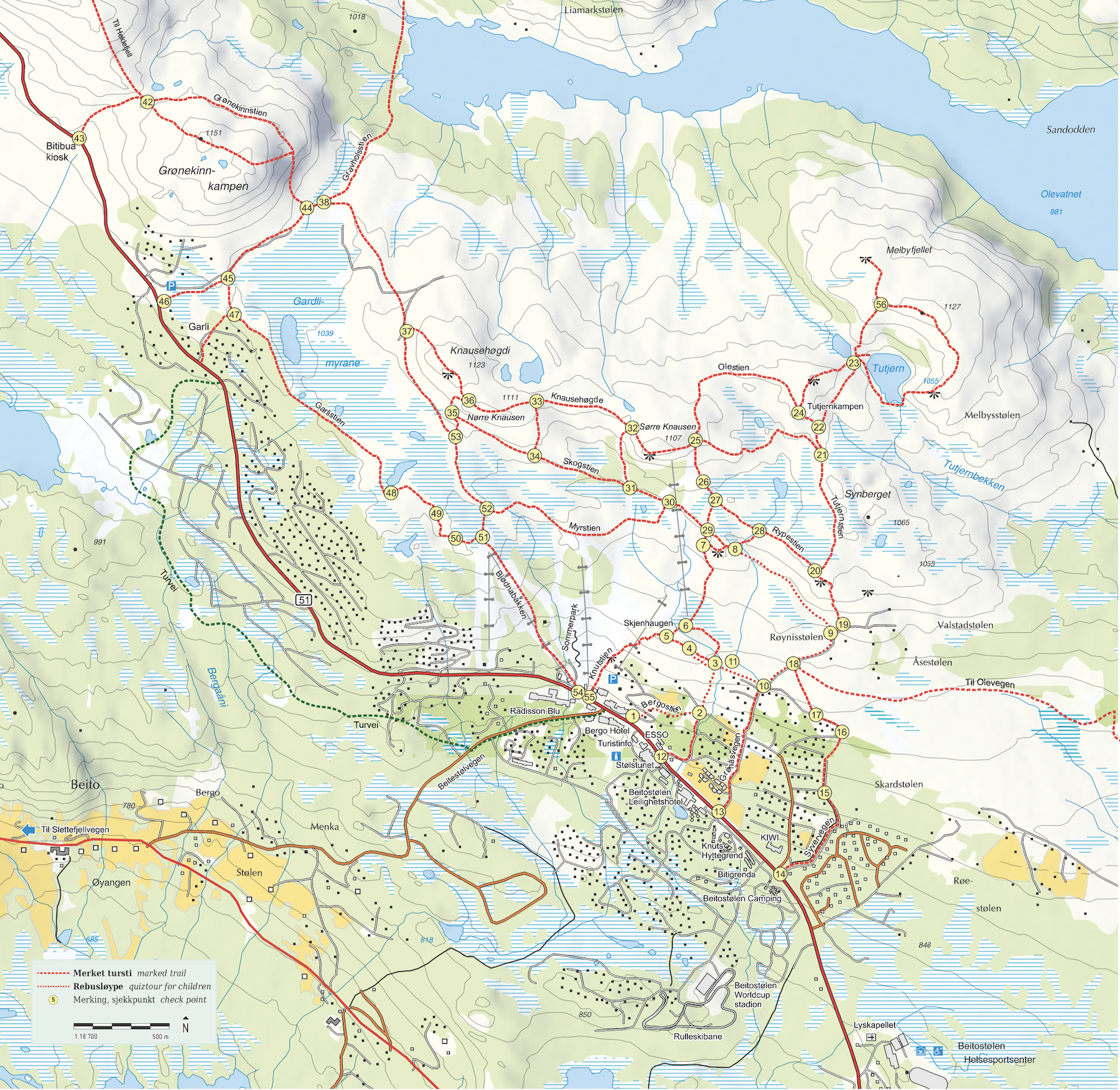
Take a look at our hiking map, which is also available at the tourist office and several locations in the town center. The map shows numbers on poles in the terrain that you can follow. Additionally, we have a fun children's puzzle trail and a path with poems along the way that we recommend. Below, we've also included descriptions of the most popular routes and some other useful information for you.

Choose Map:
The digital map shows both hiking trails and cycling routes, and you can see your current position. We’ve also uploaded an image of the paper map, which shows all the checkpoints.


View from Skjenhaugen

Finish your trip with a visit to Liastølen

Quiz Trail and Poetry

Thanks to the SpareBank 1 Foundation for supporting improvements to the trail, making it more accessible to a wider range of visitors
Anbefalte turstier
Barnerebus
REBUS OG FAMILIETUR 2,4 KM
Det er ti spørsmål langs stien som passer mindre barn. Start vis-à-vis Bergo Hotel. Følg sjekkpunkter fra 1 til 11. Stien passerer Skjenhaugen med gammelt gravfelt med rester fra tre gamle graver. Du går nesten over den ene graven. På høyden etter punkt 7 er det vakker utsikt og mange sitter ned og nyter naturen her. Et par hundre meter lenger bort er det en bekk som barna liker å leke ved. Turen går videre gjennom fjellskogen, ned Grønåsvegen og tilbake via Bergostien. Langs rebusløypa vil du oppleve naturen og stølslivet gjennom lokale og nasjonale dikt.
Tutjern og Melbyfjellet
Til Tutjern fra Beitostølen er det ca. 2,6 - 2,8 km en vei. Gå stier som passer deg best. Dette er en meget fin tur i frodig fjellnatur. Ved Tutjern er det fin rasteplass og turen er godt egnet for lek og hvile. Rundturen på Melbyfjellet er ca. 2 km - sjekkpunkt 23-56-23. Det er best å gå bratthenget opp (medsols). Det er bratt de første 15 m - gå forsiktig. Velger man Melbyrunden så kan man nyte utsikt over vakre Olevatn. Gå til utsiktpunktet og sitt ned på den flate steinen. Denne turen anbefales spesielt.
KNAUSEHØGDA - GARLIRUNDEN CA. 8 KM
Gå opp fra Beitostølen sentrum hvor det passer best. Gå forbi sjekkpunkt 32-36-44-47-51-54. Fin utsikt fra Knausehøgda i alle retninger. Garlistien går i øvre kant av fjellbjørkeskogen. Mellom stien og snaufjellet finner du spennende våtmark med myr og tjern. Kanskje får du øye på eller hører vadefuglene som holder til her.
Om stiene våres
Mange av stiene er resultat av husdyrenes gamle tråkk fra tiden da stølsdriften dominerte Beitostølen. Geiter og kuer har laget våre stier som danner et nettverk og gir oss turgåere mulighet for varierte opplevelser. I dag er det en aktiv støl på Beitostølen, mens det i 1973 var ti. Rundt Beitostølen finner vi også i dag mange aktive støler med både ku og geit, noe som opprettholder et unikt og spennende kulturlandskap. Her kan du finne en tur som passer deg og dagens værforhold. Vi har satt ut stolper med sjekkpunkter samt skilter og oversiktskart. Be oss på turistkontoret eller i resepsjonenene om hjelp hvis du ønsker. Gi oss gjerne tilbakemeldinger fra turene. Du kan starte turen fra ulike plasser langs riksvegen.
Grønåsvegen er grusveg helt opp til Åsestølen - litt tungt å gå. Syvervegen og Bergostien er lette å gå oppover. Stolheisen i Bjødnabakken kan brukes til visse tider. Skiheisene er bra referansepunkter i området. Alle heisene går mot Beitostølen.
Fjellstafetten har gjerne også turmål i dette området. I tillegg har fjellstafetten tilrettelagte turer til ni andre fine utsiktspunkt i kommunen. Turistkontoret har mer info. Ta hensyn til beitedyr og vilt - husk at det er båndtvang for hund fra 1. april til 1. oktober.
Children's Bus
PUZZLE AND FAMILY TRAIL 2.4 KM
There are ten questions along the trail suitable for younger children. Start opposite Bergo Hotel. Follow the checkpoints from 1 to 11. The trail passes Skjenhaugen with an old burial site containing remnants of three ancient graves. You'll almost walk over one of the graves. At the summit after point 7, there's a beautiful view, and many people sit and enjoy the scenery there. A few hundred meters ahead, there's a brook where kids enjoy playing. The trail leads through the mountain forest, down Grønåsvegen, and back via Bergostien. Throughout the puzzle route, you will encounter nature and mountain farm life through local and national poetry.
Tutjern and Melby Mountain
To Tutjern from Beitostølen is approximately 2.6 - 2.8 km one way. Choose the trails that suit you best. This hike offers a delightful journey through lush mountain scenery. At Tutjern, you'll find a lovely picnic area, making it an ideal spot for relaxation and play. The round trip to Melby Mountain covers about 2 km with checkpoints at 23-56-23. It's best to go up the steep slope (counter-clockwise). be careful as you ascend the first 15 m as they are steep. If you choose the Melby round trip, you can enjoy the view of beautiful Olevatn. Walk to the viewpoint and sit down on the flat stone. This trip is especially recommended.
KNAUSEHØGDA - GARLI ROUND TRIP APPROX. 8 KM
Begin your hike from Beitostølen town center, choosing the route that suits you best. Pass checkpoints 32-36-44-47-51-54. Enjoy panoramic views from Knausehøgda in every direction. The Garli trail winds along the upper edge of the mountain birch forest. As you traverse between the trail and the open mountain, discover intriguing wetlands with marshes and ponds, where you might catch sight or sound of the fluttering birds that inhabit the area.
Our Trails
Our trails trace back to the ancient paths carved by cattle during the heyday of mountain farming in Beitostølen. These paths, shaped by goats and cows, now crisscross the landscape, offering hikers a diverse range of experiences. While Beitostølen once boasted ten active mountain farms in 1973, today, we still have a vibrant farming community, maintaining the area's unique cultural landscape with both cows and goats.
Embark on a hike that suits your preferences and the day's weather conditions. We've marked checkpoints with poles, supplemented by signs and overview maps. Should you need assistance, don't hesitate to ask us at the tourist office or reception. Your feedback on the trails is always appreciated.
You can kick off your adventure from various points along the main road. Grønåsvegen, although gravelly and somewhat challenging, leads all the way up to Åsestølen. Alternatively, Syvervegen and Bergostien offer easier ascents. Keep an eye out for the chairlift in Bjødnabakken, operational during specific times. Ski lifts serve as useful landmarks, all heading toward Beitostølen.
The 'Fjellstafetten' frequently includes hiking destinations in our area, and they also arrange guided tours to nine other breathtaking viewpoints across the municipality. For more details, visit the tourist office.
As you explore, please respect the grazing animals and local wildlife. Remember, there's a leash requirement for dogs from April 1st to October 1st."